
Archivu:Localización de Melilla.png
Nu disponibri a mayol resolución.
Localización_de_Melilla.png (306 × 204 pixel, grandol el archivu: 4 kB, MIME type: image/png)
Síntesis
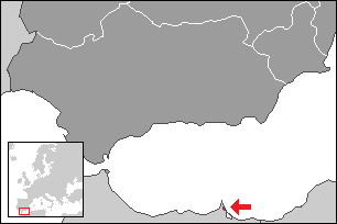
Map extent is fitted to NUTS ES3 area (Southern Spain).

|
File:Localización de Melilla.svg es una versión vectorial de este archivo. Debería usarse esa versión en lugar de este archivo PNG, cuando sea mejor.
File:Localización de Melilla.png → File:Localización de Melilla.svg
Para más información, lee Ayuda:SVG. |
 |
Licéncia:
Yo, titular de los derechos de autor de esta obra, la publico en los términos de las siguientes licencias:

|
Se autoriza la copia, distribución y modificación de este documento bajo los términos de la licencia de documentación libre GNU, versión 1.2 o cualquier otra que posteriormente publique la Fundación para el Software Libre; sin secciones invariables, textos de portada, ni textos de contraportada. Se incluye una copia de la dicha licencia en la sección titulada Licencia de Documentación Libre GNU. |
| Este archivo se encuentra bajo la licencia Creative Commons Genérica de Atribución/Compartir-Igual 3.0. | ||
| ||
| Esta etiqueta de licencia fue agregada a este archivo como parte de la actualización de la licencia GFDL. |
Puedes usar la licencia que prefieras.
Estorial el archivu
Pursa nuna fecha/ora pa vel cumu era el archivu nesi momentu.
| Fecha/Ora | Cuairu | Miias | Usuáriu | Comentáriu | |
|---|---|---|---|---|---|
| atual | 06:36 22 Ago 2015 | | 306 × 204 (4 kB) | Kontrollstellekundl | red dotted |
| 23:25 25 Dic 2009 |  | 306 × 204 (2 kB) | Martin H. | Reverted to version as of 08:09, 2 October 2006 | |
| 20:25 25 Dic 2009 |  | 250 × 189 (27 kB) | Vegggggggggggggg | {{Information |Description={{es|1=.}} |Source=. |Author=. |Date=. |Permission= |other_versions= }} | |
| 08:09 2 Otu 2006 |  | 306 × 204 (2 kB) | Martorell | == Summary == Map extent is fitted to NUTS ES3 area (Southern Spain). Category:Spain Category:Maps of autonomous communities of Spain |
Atihus
Nu ai denguna páhina qu’atihi a esti archivu.
Uso global del archivo
Las siguientis güiquis gastan esti archivuː
- Uso en en.wikipedia.org